
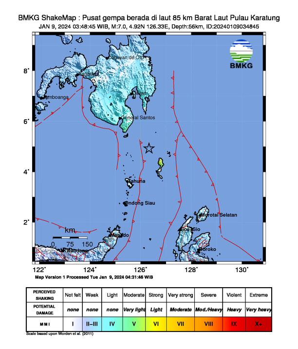
Date & time: 2024-01-08 20:48:42 (UTC)
Local time at epicenter: Tuesday, Jan 9, 2024 04:48 am
Latitude/ Longitude: 4°55'12.0"N 126°19'48.0"E
Epicenter: Philippine Sea
Magnitude: 7.0
Depth: 56.0 km

Waveform
Listen to the waveform as audio:
ShakeMap (BMKG)
ShakeMap (USGS)

Nearby towns/cities
- 85.23 km (52.96 mi) WNW of Karatung Island, Kepulauan Talaud Regency, North Sulawesi, Indonesia
- 105.24 km (65.39 mi) N of Kolongana, Kepulauan Talaud Regency, Indonesia
- 172.78 km (107.36 mi) NNE of Tahuna, North Sulawesi, Indonesia
- 185.57 km (115.31 mi) SE of General Santos City, South Cotabato, Philippines
- 251.91 km (156.53 mi) S of Davao City, Philippines
- 286.99 km (178.33 mi) S of Tagum, Davao del Norte, Philippines
MMI (Modified Mercalli Intensity) Scale:
- VI Essang
- V Beo
- V Rainis
- V Sarangani
- V Bukid
- V Lirung
- IV General Santos
- IV Polomolok
- IV Digos
- IV Koronadal
- IV Mati
- IV Kepulauan Sangihe
- IV Kepulauan Talaud
- III Bitung
- II-III Halmahera Utara
- II Manado
Find us on
- Instagram: earth4444_
- Tiktok: @earth.44_
- Telegram: earthquake44
- Youtube: @earth44